
Create, display, and evaluate geodata with QGIS
Map Game

Create and display geospatial data with the versatile and popular QGIS.
Most modern mapping information is not stored as a single complete picture, the way it used to be when you found your geographic information from a map on a wall or in an atlas. Maps have become fully integrated with the digital revolution. The map you view from your computer screen or telephone is transmitted to the device as a bundle of geospatial information that is stored in a file or database. An application on the receiving device assembles this data into a view that the user can recognize as a map.
This geospatial data is available online from many sources, including research institutions, government agencies, and nonprofit groups. Of course, it is also possible to create your own geographical information file, which is the modern equivalent of drawing your own map. Another option is somewhere between the alternatives of downloading or rolling your own: Many users start with public information and then customize the map by adding their own annotations and features.
Linux supports numerous Geographical Information System (GIS) tools that help to create, edit, analyze, and visualize geospacial data. One of the most popular GIS solutions is QGIS [1]. The Quantum-GIS geographical tool, which has undergone continuous development since 2002, is licensed under GPLv2 and available for several platforms.
QGIS uses a PostgreSQL database with the PostGIS extension to capture geographical elements. The modular structure of the software allows the user to extend the functionality by adding plugins. QGIS also supports interfaces to OpenStreetMap, GRASS GIS, and various statistics programs. The system can handle all common vector and raster graphics formats.
With its simple user guidance and sophisticated display functions, QGIS has established itself as an important tool for research professionals. Excellent multilingual documentation and tutorials mean that the software is also quite accessible to beginners.
Installation
You will find precompiled QGIS packages in the repositories of all major Linux distributions; however, if you want to be sure you have the most recent version, manual setup is a better option. The project website provides detailed documentation on integrating QGIS into various systems [2]. Be sure to read the notes on supported operating system versions, because not all program versions work with all Linux distributions due to missing dependencies. For some Debian derivatives, you must first install the apt-transport-https package, because the QGIS repositories work with SSL encryption.
To start QGIS, click QGIS Desktop in the Start menu. First, a configuration window lets you decide whether to transfer data from a previous version. After you click on one of the options, the program window opens. The window appears largely empty for new installations without imported data (Figure 1). The main window is divided into five sections: At the top, you will find an extensive menubar and a buttonbar. On the left, a browser and a layer area appear below each other, and on the right you will see a list of recently edited projects.
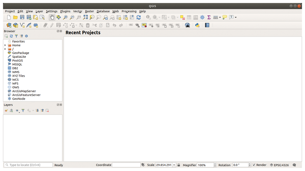 Figure 1: The left panel of the main window hints at the wealth of possibilities offered by QGIS.
If you load one of your projects, the map view appears in the right window area. The browser and layer areas display the map elements in a tree view. The browser displays data carriers, linked geodatabases, and map services; the layers represent the different levels of a map. The software visualizes the layers hierarchically, so that moving or (de-)activating the individual layers changes the map image accordingly. A status bar at the bottom of the window provides information on coordinates, scale, and magnification of the map.
Individual
The flexible interface can easily adapt to your ideas. For example, minimizing the layer and browser view creates more space for the map. You can place individual window segments anywhere by dragging the titlebar while holding down the left mouse button. To switch the window segments completely on and off, use the dialog panels in the View menu.
The toolbar consists of individual tool groups that you can move individually to the margins of the program window and arrange vertically. If necessary, switch complete tool groups on or off via View | Toolboxes.
To remove individual unneeded buttons from the toolbars, open the Settings | Interface Customizations… menu and check the Enable customizations option in the overlaying window. You can then navigate through the individual menu hierarchies and deactivate unnecessary options by unchecking the boxes (Figure 2). To apply the changes, restart the software.
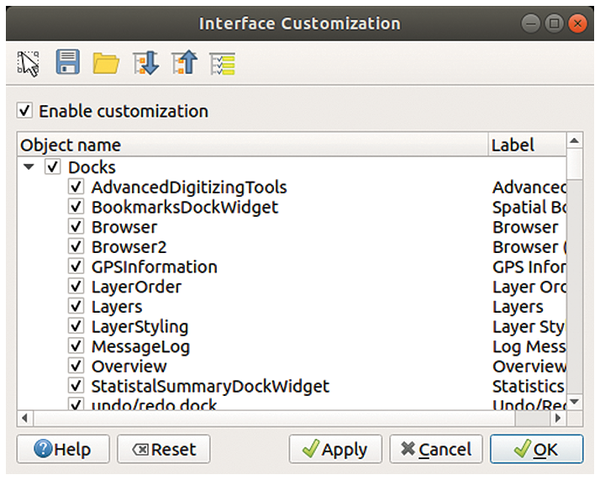 Figure 2: Activate or deactivate the control elements in the Interface Customization dialog box.
For friends of shortcuts, QGIS offers the option of defining individual shortcuts for different functions in the Settings | Shortcuts menu. In the Settings | Options dialog, you can also adjust the font and icon size to your requirements. This function is particularly useful for very high-resolution screens, since the default size for icons and fonts on screens beyond FHD resolutions (1920x1080 pixels) often appear too small.
Mess of Data
Many public institutions provide data on a variety of topics for free download over the web. Other geographical data is available in the form of Web Map Service files (WMS) on the servers of public institutions.
QGIS lets you load this free geographical data into a new or existing project. In the menubar in the Layer | Add Layer menu, you will find various options for creating a new map layer. Depending on the data format, you have to differentiate between vector and raster data. You can also integrate a database into the software, and you can then localize and load the data in a small file manager on the local mass storage system. The software supports several common database formats.
The downloaded data appears on the left in the layer area.
You can complete this task more elegantly in the browser area, which also contains a small file manager. From the browser area, you can transfer the data using drag-and-drop. If several geo files are in the directory, right-click on the desired file and select Add Selected Layer(s) to Map (Figure 3).
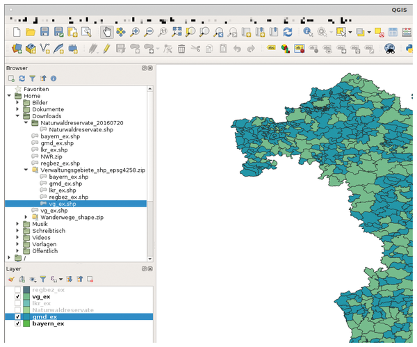 Figure 3: Maps consist of several independent layers, which QGIS lists on the lower-left corner.
Buy this article as PDF
(incl. VAT)
Buy Linux Magazine
US / Canada
UK / Australia
Subscribe to our Linux Newsletters
Find Linux and Open Source Jobs
Subscribe to our ADMIN Newsletters
Support Our Work
Linux Magazine content is made possible with support from readers like you. Please consider contributing when you’ve found an article to be beneficial.

News
-
Linux Servers Targeted by Akira Ransomware
A group of bad actors who have already extorted $42 million have their sights set on the Linux platform.
-
TUXEDO Computers Unveils Linux Laptop Featuring AMD Ryzen CPU
This latest release is the first laptop to include the new CPU from Ryzen and Linux preinstalled.
-
XZ Gets the All-Clear
The back door xz vulnerability has been officially reverted for Fedora 40 and versions 38 and 39 were never affected.
-
Canonical Collaborates with Qualcomm on New Venture
This new joint effort is geared toward bringing Ubuntu and Ubuntu Core to Qualcomm-powered devices.
-
Kodi 21.0 Open-Source Entertainment Hub Released
After a year of development, the award-winning Kodi cross-platform, media center software is now available with many new additions and improvements.
-
Linux Usage Increases in Two Key Areas
If market share is your thing, you'll be happy to know that Linux is on the rise in two areas that, if they keep climbing, could have serious meaning for Linux's future.
-
Vulnerability Discovered in xz Libraries
An urgent alert for Fedora 40 has been posted and users should pay attention.
-
Canonical Bumps LTS Support to 12 years
If you're worried that your Ubuntu LTS release won't be supported long enough to last, Canonical has a surprise for you in the form of 12 years of security coverage.
-
Fedora 40 Beta Released Soon
With the official release of Fedora 40 coming in April, it's almost time to download the beta and see what's new.
-
New Pentesting Distribution to Compete with Kali Linux
SnoopGod is now available for your testing needs