
Online services that extend the capabilities of OpenStreetMap
OpenRouteService
OpenRouteService (ORS) [8] is similar to Naviki, but a little different and with different results. The procedure for planning routes is similar: First select the start and end points and the desired vehicle type from the context menu. You can add additional points to the route with a mouse click (Figure 7).
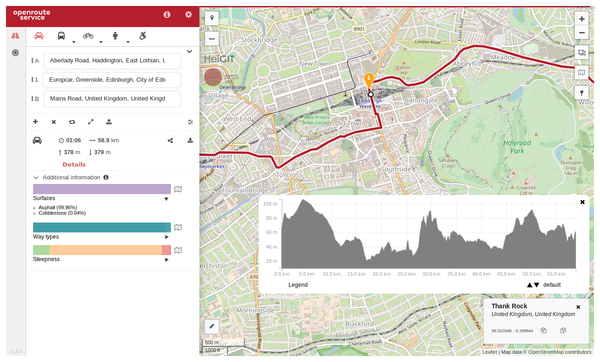 Figure 7: ORS creates routes for cars, bicycles, or pedestrians.
If necessary, the automatically selected route can be further adjusted via Options. For instance, you can elect to avoid certain types of routes, ferry trips, or hills, or you can choose to limit the maximum gradient. You can also optimize the route selected by ORS by entering your own fitness level and top speed (Figure 8).
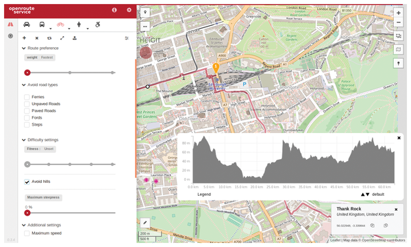 Figure 8: ORS lets you confine the route to a predefined maximum speed and gradient.
A real benefit of ORS is found below the route summary: An overview informs you about the road surface condition (Asphalt, Paved, Compacted Gravel, etc.), the way types (State road, Cycleway, etc.) or the steepness. If you mouse over one of the bars, ORS marks the corresponding sections on the map. This makes it easy to check whether the chosen route meets your own requirements – for example, riding a racing bike over rough gravel is not much fun.
You can save the results of your planning using the Export Route button, which can be found next to the route details such as travel time, distance, and altitude, in the form of a GPX track on your hard disk. Alternatively, the KML, GeoJSON, or JSON formats are also available.
Overpass Turbo
The OSM developers have continuously improved access to their database. One of the last and very successful enhancements to OSM is Overpass Turbo [9]. OSM calls Overpass Turbo a data collection tool, but it is also a powerful tool for finding data in the database.
One special feature of OverPass Turbo is its impressive speed, which is the reason why they call it "Turbo." You can create a query that you then send to the OSM database (Listing 1), and Overpass Turbo displays an interactive map with the hits (Figure 9).
Listing 1
Overpass Query
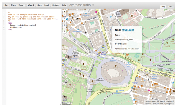 Figure 9: Overpass Turbo lets you search for a service or amenity and marks the matches with circles.
The example given on the page searches the current map section for freely accessible drinking water points. You don't necessarily have to familiarize yourself with programming the tool; a wizard helps you create the queries.
The Overpass Turbo query language contains some special elements: {{bbox}} stands for the currently displayed map area, and {{date}} allows time restrictions. There are a number of other ways to restrict the output. An article in the OSM Wiki describes the syntax of the queries in detail [10].
The page can also be accessed via a number of key combinations. Ctrl+Enter starts the current query, Ctrl+I opens the wizard, Ctrl+S saves a query, and Ctrl+O lets you reload stored queries. Ctrl+Z and Ctrl+Y (undo and redo) are available, as well as Ctrl+X, Ctrl+C, and Ctrl+V (cut, copy, and paste).
After you enter a query, Overpass Turbo displays a page with markers. This result can be saved in different ways using the Export button. In addition to a static output as a PNG image, Overpass Turbo also provides the formats XML, GPX, JSON, and GeoJSON. If the details of Overpass Turbo queries are too much trouble, you might want to consider OSM's POI Viewer (see the box entitled "OSM POI Viewer").
OSM POI Viewer
The OSM POI Viewer [11] (Figure 10) offers a far simpler alternative to Overpass Turbo. The idea behind the POI Viewer is quite simple: On the left, first select the desired POI category from the sidebar, and then the page automatically starts the database query and creates a layer overlaid with the POIs. Depending on the size of the area displayed and the number of POIs selected, this can happen very quickly, or it can take a few seconds. The big advantage of this site is the very easy handling, but the rigid rules applied by the page limit your options.
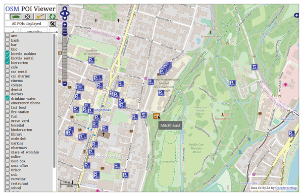 Figure 10: OSM POI Viewer helps you quickly find interesting points on the map, such as cycle parking lots and beer gardens.
Topographic Maps
OSM includes current paths and roads, as well as outlines of cities, municipalities, or forests and rivers, but it lacks elevation data. The map service itself does not support contour lines or a topographical view; only summits and heights are recorded. Therefore, maps with terrain surfaces cannot easily be derived from OSM; you need to add data from other sources.
OpenTopoMap [12] provides a view of terrain surfaces (Figure 11). Other tools, such as HikeBikeMap [13] and the Riding and Hiking Map [14], also provide topographical services, but they are primarily focused on Europe.
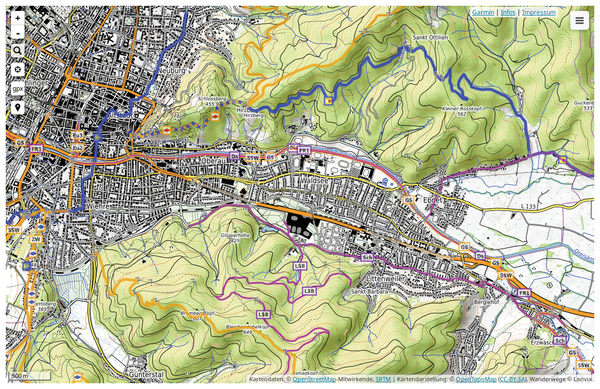 Figure 11: OpenTopoMap displays detailed contour lines.
« Previous 1 2 3 Next »
Buy this article as PDF
(incl. VAT)
Buy Linux Magazine
US / Canada
UK / Australia
Subscribe to our Linux Newsletters
Find Linux and Open Source Jobs
Subscribe to our ADMIN Newsletters
Support Our Work
Linux Magazine content is made possible with support from readers like you. Please consider contributing when you’ve found an article to be beneficial.

News
-
TUXEDO Computers Unveils Linux Laptop Featuring AMD Ryzen CPU
This latest release is the first laptop to include the new CPU from Ryzen and Linux preinstalled.
-
XZ Gets the All-Clear
The back door xz vulnerability has been officially reverted for Fedora 40 and versions 38 and 39 were never affected.
-
Canonical Collaborates with Qualcomm on New Venture
This new joint effort is geared toward bringing Ubuntu and Ubuntu Core to Qualcomm-powered devices.
-
Kodi 21.0 Open-Source Entertainment Hub Released
After a year of development, the award-winning Kodi cross-platform, media center software is now available with many new additions and improvements.
-
Linux Usage Increases in Two Key Areas
If market share is your thing, you'll be happy to know that Linux is on the rise in two areas that, if they keep climbing, could have serious meaning for Linux's future.
-
Vulnerability Discovered in xz Libraries
An urgent alert for Fedora 40 has been posted and users should pay attention.
-
Canonical Bumps LTS Support to 12 years
If you're worried that your Ubuntu LTS release won't be supported long enough to last, Canonical has a surprise for you in the form of 12 years of security coverage.
-
Fedora 40 Beta Released Soon
With the official release of Fedora 40 coming in April, it's almost time to download the beta and see what's new.
-
New Pentesting Distribution to Compete with Kali Linux
SnoopGod is now available for your testing needs
-
Juno Computers Launches Another Linux Laptop
If you're looking for a powerhouse laptop that runs Ubuntu, the Juno Computers Neptune 17 v6 should be on your radar.