
Geotag photos with Geotag

Productivity Sauce
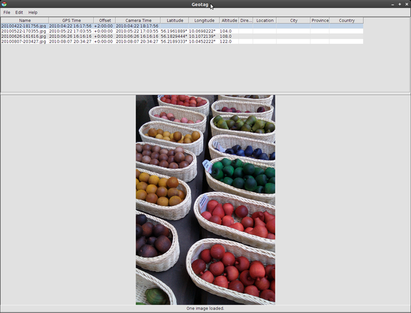
Need to quickly geotag a bunch of photos? A little nifty utility aptly named Geotag is the perfect tool for the job. Since Geotag is w ritten in Java, you must have the Java Runtime Environment installed on your machine to be able to run the utility. Geotag relies on an external tool called exiftool, a Perl script that enables the writing of EXIF metadata. The tool is available in the software repositories of many Linux distributions, so you can install it using your distro's package manager. On Ubuntu, you can do this by running the sudo apt-get install libimage-exiftool-perl command. If you want to use Geotag with RAW files, you should also install the dcraw utility. Launch then Geotag, choose File | Settings, and navigate to the Settings | External programs | Exiftool | Exiftool path. Enter the path to exiftool in the Exiftool path field (e.g., /usr/bin/exiftool) and press OK.
If you have a GPS receiver, you can use the utility to sync photos with GPX tracks. Geotag can load tracks directly from the GPS receiver via the File | Load tracks from GPS command, or you can point the application to a GPX file using the File | Load tracks from file command. But what if you don't have a GPS receiver? In this case, you can use a simple trick to obtain the latitude and longitude via Google Maps. Use the service to find the location you need, then enter the following code snippet in the address bar and hit Enter:
javascript:void(prompt('',gApplication.getMap().getCenter()));This will return the latitude and longitude of the specified location. Now you are ready to do some geotagging. Choose File | Add image or Add images from directory to add one or multiple photos. Alternatively, you can drag and drop photos from your desktop into Geotag. Copy the obtained latitude and longitude values into the appropriate fields in Geotag, and you are done.
The Copy location command allows you to copy the coordinates of the currently selected photo into other images in the batch, which can come in handy if you have taken multiple pictures at the same location. Geotag also sports a clever Select feature (Edit | Select), which you can use to select photos without coordinates or with new (unsaved) coordinates. This makes it significantly easer to geotag the selected photos without touching other pictures. To save the added geotags, right-click on a photo and choose the Save new locations command.
Now that you've geotagged your photos (or loaded already tagged photos), you can use Geotag to map them using either the Google Maps service or the Google Earth application. To do this, right-click on the photo you want to map and choose Show on map. Using the available options, you can map the currently selected picture or all photos in one go. The Google Earth command allows you not only to display a single or multiple photos in Google Earth, but also to create a KML file, which you can use later to open your photos in Google Earth -- perfect for showing your travel photos to others. For a better effect, you might want to add thumbnail previews of your photos to the KML file. To do this, choose File | Settings | Export | Google Earth and enable the Store thumbnails in the KMZ files option.
comments powered by DisqusSubscribe to our Linux Newsletters
Find Linux and Open Source Jobs
Subscribe to our ADMIN Newsletters
Support Our Work
Linux Magazine content is made possible with support from readers like you. Please consider contributing when you’ve found an article to be beneficial.

News
-
Kali Linux Waxes Nostalgic with BackTrack Mode
For those who've used Kali Linux since its inception, the changes with the new release are sure to put a smile on your face.
-
Gnome 50 Smooths Out NVIDIA GPU Issues
Gamers rejoice, your favorite pastime just got better with Gnome 50 and NVIDIA GPUs.
-
System76 Retools Thelio Desktop
The new Thelio Mira has landed with improved performance, repairability, and front-facing ports alongside a high-quality tempered glass facade.
-
Some Linux Distros Skirt Age Verification Laws
After California introduced an age verification law recently, open source operating system developers have had to get creative with how they deal with it.
-
UN Creates Open Source Portal
In a quest to strengthen open source collaboration, the United Nations Office of Information and Communications Technology has created a new portal.
-
Latest Linux Kernel RC Contains Changes Galore
Linux kernel 7.0-rc3 includes more changes than have been made in a single release in recent history.
-
Nitrux 6.0 Now Ready to Rock Your World
The latest iteration of the Debian-based distribution includes all kinds of newness.
-
Linux Foundation Reports that Open Source Delivers Better ROI
In a report that may surprise no one in the Linux community, the Linux Foundation found that businesses are finding a 5X return on investment with open source software.
-
Keep Android Open
Google has announced that, soon, anyone looking to develop Android apps will have to first register centrally with Google.
-
Kernel 7.0 Now in Testing
Linus Torvalds has announced the first Release Candidate (RC) for the 7.x kernel is available for those who want to test it.