
Optimizing and visualizing GPS data
Climbing Aid
Handheld navigation devices point the way and continuously record your position while you are walking. With a few scripts on Linux, extreme climber Mike Schilli attractively visualizes the data from some of his bold first ascents.
Every smartphone features a GPS receiver nowadays, and a generous collection of apps are guiding hikers across hill and dale by displaying maps. Of course, things can be pretty rustic out there in the wild, and it is a good idea to use more robust, water-splash protected devices with more powerful batteries. Some time ago, I purchased a Garmin 62s – on special offer. Although it might be a little outmoded by now, it looks as if you could drive a tank over it without causing any damage.
If you are spoiled by years of intuitive on-screen operation with your smartphone, you will probably be rubbing your eyes in disbelief to discover that LCD displays with weird menu designs – in which the user has to steer the cursor with a dozen plastic buttons on the front of the device – really do still exist (Figure 1).
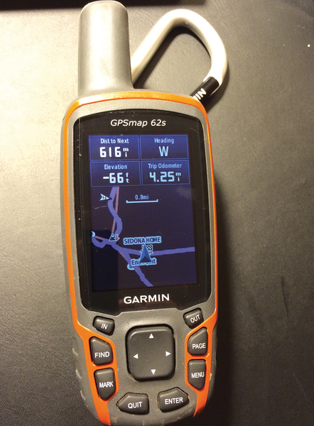 Figure 1: The Garmin GPSmap 62s.
[...]
Buy this article as PDF
(incl. VAT)
Buy Linux Magazine
Subscribe to our Linux Newsletters
Find Linux and Open Source Jobs
Subscribe to our ADMIN Newsletters
Support Our Work
Linux Magazine content is made possible with support from readers like you. Please consider contributing when you’ve found an article to be beneficial.

News
-
Hannah Montana Linux Is Back!
Developer Noah Cagle decided the world needed the once obscure but beloved Linux distribution and gave it a decidedly pink refresh.
-
System76 Refreshes the Lemur Laptop
If you're looking for a laptop with tons of power and battery, look no further than the latest iteration of the System76 Lemur Pro.
-
More than 43 Million Lines of Code in Linux Kernel 7.2
Using the cloc utility, Michael Larabel of Phoronix discovered that Linux kernel 7.2 has over 43 million lines of code.
-
Kubuntu Focus Goes Ultra
The Kubuntu Focus team has upped the performance ante of its M2 and Zr laptops with the latest, greatest CPUs from Intel.
-
Linux Gamers May Soon See Less Mouse Lag in KDE Plasma
Gamers using KDE’s Plasma desktop have been suffering from a slight input delay in mouse movement that could lead to getting fragged.
-
Three Lines of Code Improve Linux Storage Performance
A developer changed three lines of code, giving Linux storage performance a 5% bump.
-
AUR Hit Again with Malicious Packages
Once again the Arch User Repository is plagued by a high volume of malicious packages.
-
Alpine Linux 3.24 Features Fresh Desktops and a Newer Kernel
If you're a fan of Alpine Linux, it's time to upgrade because the latest version has been released with KDE Plasma 6.6, Gnome 50, and Linux kernel 6.18 LTS.
-
EU Open Source Strategy Plays Key Role in Tech Sovereignty Package
Comprehensive measures adopted by the European Commission aim to reduce dependency on non-EU countries.
-
Linux Foundation Report Indicates AI Driving Tech Hiring
Within growing security and skills gaps, AI has been found to be a positive driving force behind tech hiring trends in Europe.