
Photo location guessing game in Go
After the resounding success of the Wordle [1] word guessing game, it didn't take long for the first look-alikes to rear their heads. One of the best is the entertaining Worldle [2] geography game, where the goal is to guess a country based on its shape. After each unsuccessful guess, Worldle helps the player with information about how far the guessed country's location is from the target and in which direction the target country lies.
Not recognizing the outline of the country in Figure 1, a player's first guess is the Principality of Liechtenstein. The Worldle server promptly tells the player that the target location is 5,371 kilometers away from and to the east of this tiny European state. The player's second guess is Belarus, but according to the Worldle server, from Belarus you'd have to travel 4,203 kilometers southeast to get to the target. Mongolia, the third attempt, overshoots the mark, because from there you'd have to go 3,476 kilometers to the southwest to arrive at the secret destination.
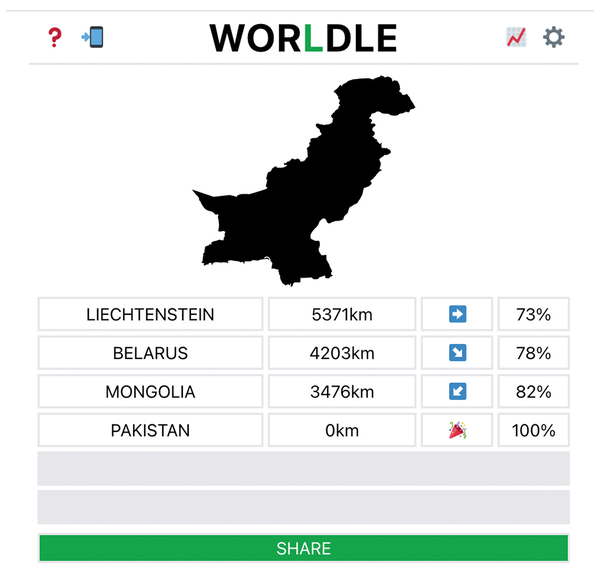 Figure 1: The original Worldle geography guessing game.
[...]
Buy this article as PDF
(incl. VAT)
Buy Linux Magazine
Subscribe to our Linux Newsletters
Find Linux and Open Source Jobs
Subscribe to our ADMIN Newsletters
Support Our Work
Linux Magazine content is made possible with support from readers like you. Please consider contributing when you’ve found an article to be beneficial.

News
-
CIQ Releases Compatibility Catalog for Rocky Linux
The company behind Rocky Linux is making an open catalog available to developers, hobbyists, and other contributors, so they can verify and publish compatibility with the CIQ lineup.
-
KDE Gets Some Resuscitation
KDE is bringing back two themes that vanished a few years ago, putting a bit more air under its wings.
-
Ubuntu 26.04 Beta Arrives with Some Surprises
Ubuntu 26.04 is almost here, but the beta version has been released, and it might surprise some people.
-
Ubuntu MATE Dev Leaving After 12 years
Martin Wimpress, the maintainer of Ubuntu MATE, is now searching for his successor. Are you the next in line?
-
Kali Linux Waxes Nostalgic with BackTrack Mode
For those who've used Kali Linux since its inception, the changes with the new release are sure to put a smile on your face.
-
Gnome 50 Smooths Out NVIDIA GPU Issues
Gamers rejoice, your favorite pastime just got better with Gnome 50 and NVIDIA GPUs.
-
System76 Retools Thelio Desktop
The new Thelio Mira has landed with improved performance, repairability, and front-facing ports alongside a high-quality tempered glass facade.
-
Some Linux Distros Skirt Age Verification Laws
After California introduced an age verification law recently, open source operating system developers have had to get creative with how they deal with it.
-
UN Creates Open Source Portal
In a quest to strengthen open source collaboration, the United Nations Office of Information and Communications Technology has created a new portal.
-
Latest Linux Kernel RC Contains Changes Galore
Linux kernel 7.0-rc3 includes more changes than have been made in a single release in recent history.